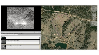
The additional use of MISB, FMV, files allows the software the additional layer of adding the sensor footprint, where the camera is looking, in additional to the cameras physical location to the feedback. In the first image below the red line represents the the aircraft flight track, where the green dot is the current location. The second image depicts where the actual image is in relation to the surface of the earth.
Friday, December 7, 2018
Adding GPS situational awareness to full motion video.
There is software available, free according to their website, That allows you to take any video that has GPS metadata embedded and display the location of where the video was recorded on google maps. The company Remote GeoSystmes Inc. calls it "moving -Track" and it brings a heighten level of situational awareness that was not easily available to commercial drone operations. Benefits of using this software include; moving target tracking, emergency situations location services, extreme sport track map visualizations and anything else that the location of the flight or target would be benefit from being able to conceptualize on a map background. The idea of taking coordinates of what your UAS video is looking at and being able to put a map location to it is an invaluable resource for many applications. Not many of use can read GPS data and then mental depict its location, this software does that for you.
The additional use of MISB, FMV, files allows the software the additional layer of adding the sensor footprint, where the camera is looking, in additional to the cameras physical location to the feedback. In the first image below the red line represents the the aircraft flight track, where the green dot is the current location. The second image depicts where the actual image is in relation to the surface of the earth.
The additional use of MISB, FMV, files allows the software the additional layer of adding the sensor footprint, where the camera is looking, in additional to the cameras physical location to the feedback. In the first image below the red line represents the the aircraft flight track, where the green dot is the current location. The second image depicts where the actual image is in relation to the surface of the earth.
Subscribe to:
Post Comments (Atom)


No comments:
Post a Comment